Map-Based Vision for Restoring
the Black-tailed Prairie Dog Ecosystem
By Jonathan Proctor, Fall 2001
Predator Conservation Alliance created the focus area map (see below) based on the locations of large blocks of suitable habitat on publicly owned lands, whether occupied by prairie dogs or not. Further consideration was given to existing and historic large prairie dog complexes. Information initially compiled defined the historic range of the black-tailed prairie dog. We mapped all potential habitat currently remaining within the historic range by identifying all lands with both:
•Slopes of 10 percent or less (from 1:250,000 U.S. Geological Survey Digital Elevation Model data); and
•Vegetation classified as grasslands, shrub lands, dry salt flats or transitional barren areas (from 1:250,000 U.S. Geological Survey land use/land cover data). Plowed lands, urban lands, forests, water and all other obviously unsuitable lands were excluded.
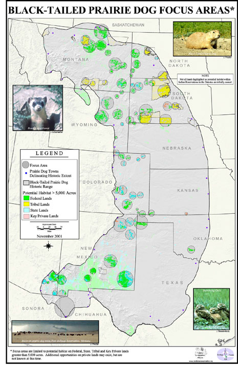 We then gathered all the land ownership data we could find within the historic range, and identified all the suitable prairie dog habitat on federal, state, tribal and key private lands of 5,000 contiguous acres or greater. From these areas, we selected the best focus areas with special consideration for locations overlapping with existing and known historic large prairie dog complexes.
The resulting map clearly depicts the best opportunities for prairie dog ecosystem restoration across the Great Plains.
A few notes: this map represents a maximum area of potential habitat on federal, state and tribal lands. Some areas identified as “potential” may not be suitable due to the limits of available data (including scale) and conditions not considered. We believe that this map is, however, adequate for its purpose—identification of logical focus areas for prairie dog ecosystem restoration. More detailed analysis for the areas selected will be needed, and Predator Conservation Alliance has already done this for focus areas in Montana.